eThekwini has the largest number of informal settlements of any municipality in South Africa. Currently, it houses over 580 urban informal settlements encompassing 314,000 households, which comprises over a quarter of the city’s population. Continued urbanization and a swingling supply of well-located land have resulted in a multitude of vulnerabilities experienced by its population.
Background
At the rate of 4,000 new informal settlement households per year, it would take nearly 80 years to overcome the informal settlement backlog through conventional housing projects. Recognizing this, the city has launched a series of initiatives, including full-service housing projects and land management mechanisms.
To develop a pipeline of upgrading and service delivery projects, the City needs accurate information about the number and location of informal structures, as well as environmental constraints which could prevent the provision of basic services and subsidized housing.
However, eThekwini has faced various data challenges within the informal settlements’ space, which compromises strategic decision making. In response, the City has developed the Informal Settlement Information Management Solution (ISIMS) with the support of the UK Prosperity Fund (UKPF). ISIMS is a multi-year programme that looks to “facilitate improved collection, integration, and analysis of city-level data”, with the key objective of utilizing this information management solution as a planning tool.
UNITAC x eThekwini: Accelerating Spatial Recognition of Informal Settlements for Efficient Service Delivery
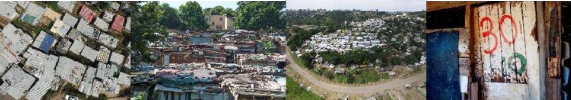
In line with eThekwini's efforts to improve its data management, the joint project with UNITAC Hamburg aims to aid its land monitoring process. The ongoing land monitoring procedure produces information on informal settlements but is struggling to keep up to pace with the fast land-use changes. In addition to on-ground land monitors that identify informal structures, the structures are also manually marked on aerial photography. Unfortunately, with 15 land monitors being responsible for 587 informal settlements, the identification process is extremely time-consuming. The workflow has greatly limited the city’s capacity to respond to resident needs efficiently and effectively.
The joint UNITAC project is developing a tool that uses machine learning to radically accelerate the spatial recognition of these settlements and structures on satellite imagery and/or aerial photography. This will allow the city to have up-to-date records of its informal settlements, as well as to keep track of density changes in the areas of discussion. In addition to the development of a machine learning algorithm that can capture information relating to informal settlements, UNITAC will facilitate the knowledge and skill transfers required for the effective implementation of the model within eThekwini’s existing system architecture. The objective of this collaboration is to enable the eThekwini Municipal Government to better, and more effectively, target their upgrading and service delivery interventions.